This edition combine Charts 1:500000 ; 1:1000000 ; 1:2000000 ; 1:4000000 for an optimized display of all aeronautical data at every zoom level.
The Argentina Buenos Aires VFR Charts cover 100% of the country territory.
The Charts has all the AIP information combine with Private data, carefully checked and updated through a triangular checking process, to guarantee the quality of the data displayed.
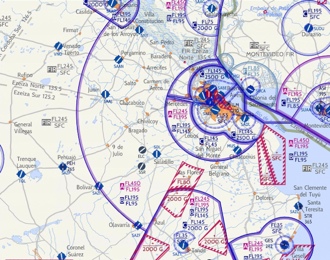
This full-colour VFR chart covers the airspaces of Argentina Buenos Aires. It is loaded with valuable aviation data including airport info; airspace dimensions; VHF and LF/MF navigational facilities (frequency, ID, and channel); landmarks; cities & towns; elevation/topographic info; ATC entities and associated contact/radio frequencies; bodies of water; obstructions; and much, much more. This VFR chart has been developed to reduce workload and improve readability. It offers you all valuable aviation data you need to plan your flight.