Digital VFR aeronautical charts available on GEOTIFF format, PNG, and a range of custom formats. Ideal for Flight planning and Moving map application and software.
This edition combine Charts 1:500000 ; 1:1000000 ; 1:2000000 ; 1:4000000 for an optimized display of all aeronautical data at every zoom level. The Philippines VFR Charts cover 100% of the country territory. The Charts has all the AIP information combine with Private data, carefully checked and updated through a triangular checking process, to guarantee the quality of the data displayed.
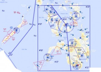
This full-colour VFR chart covers the airspaces of the Philippines. It is loaded with valuable aviation data including airport info; airspace dimensions; VHF and LF/MF navigational facilities (frequency, ID, and channel); landmarks; cities & towns; elevation/topographic info; ATC entities and associated contact/radio frequencies; bodies of water; obstructions; and much, much more. This VFR chart has been developed to reduce workload and improve readability. It offers you all valuable aviation data you need to plan your flight.
Our maps contain all the aeronautic data that you need during your VFR flights
Topographic data ( Water bodies & Lakes, Rivers & Water lines, Built-up areas )
Elevation data ( Mora grid & Spot elevation )
Thoroughfares ( Highways & “Middle roads”, Major/Primary, Secondary, Rails )
Navigation ( DME, VOR/DME, VORTAC, VOR, NDB, TACAN )
Aerodrome ( Private and Public Aerodromes, Sport Aviation )
Airspaces (All class Airspaces : AAR, SENS, ATC, HF, A, C, D, Danger, E, FIR, Restricted, E Frequency, CTR C & D) Military CTR, G, FIA)
Want to buy it? Please check our partner’s page for more details
© 2016, Flyermaps